Confluence and Influence.

We Have Come so Far, One Wonders, How Far We Can Go?

The Klamath River Watershed is a convoluted landscape shaped by colliding tectonic plates, fire and ice. For Modern Man, it is ripe with political dilemmas, survival needs and ethical nightmares.

Clockwise: Klamath Marsh Refuge, Crooked Creek, Iron Gate Dam, Klamath River Estuary, Sugar Loaf Mtn - Ishi Pishi Falls and rafting on Upper Klamath River.

Anders Tomlinson spent 13 years looking, listening, filming and recording in the Klamath River Watershed. He had several watershed moments including the day he read in the newspaper that Sacramento River interests were fighting Trinity River interests over water to protect environmentally endangered salmon in both the Sacramento and Trinity Rivers. Both sides had federal lawyers facing off against each other in court. What does one do? What do we do?  

It Is Helpful To Know Where We Came From to Understand Where We Are..

Trinity River is Klamath River's largest tributary and important salmon habitat.

The first European miners-settlers, traveling from the mouth up the Klamath River enroute to build a mining settlement, which is now Happy Camp, thought the Trinity River was the main-stem and the Klamath River was a tributary. The underwater canyon that is carved in the ocean bottom off Klamath California was named Trinity Canyon not Klamath Canyon. The miners promptly set the forests on fire.  It was the easiest way to reach bare ground in a land of steep canyon walls.  When the winds were right the smoke choked Portland.  Nautical maps made note of smoke off the coast as a navigational hazard. That was then.

Today, there is a need to rethink our ideology on a host of issues including those considered politically correct or untouchable. Here is an opportunity to refocus man’s relationship in, not to, nature. Food, water and shelter are in jeopardy for all stake-holders and species. Welcome to the age of Anthropocene. Welcome to the Klamath River Watershed. This is now. For geographical and historic background visit Klamath River Watershed in pictures and words.

Watersheds are for flora and fauna. Watersheds change over time.

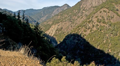
Mountain shadow and the Trinity River, photo by Anders Tomlinson.

This is what the Klamath River Watershed looks like. Where's the Basin?

The Klamath River Watershed, see video, is clearly defined. Waters flow downhill to creeks, streams and rivers that flow to the Klamath and Trinity rivers, which join some 40 miles from the Pacific Ocean, and empties into the sea. This is exact – no room for interpretation.  It is a place with absolute boundaries. Water flows this way or that way.  The Klamath Basin is a headline that means different things at different times to different folks. As example: in a judge’s decision that returned water management to the flows required by Hardy phase 2 she described the Klamath Basin as being the land that makes up the Klamath Reclamation Project and later on in the decision as being all the lands that are coho habitat.  Two different worlds.  If a judge is confused about where is where what can we expect from the general public or public servants?

George Lewis interviews Upper Klamath Reclamation Project farmer Ty Kliewer during the summer of 2001.  Photo by Anders Tomlinson.

NBC's George Lewis interviews Ty Kliewer during the summer of 2001.


In 2001, several young farmers interviewed by national media kept trying to say the salmon issue was about a much larger watershed – not just the twenty some miles that makes up the Klamath Reclamation Project. The media would not listen. European media did listen and reported as such.  The National Academy of Science, 12 good scientists from around the country who spent three years studying the 2001 salmon-water shutoff, determined it was not a Klamath Basin problem – it was a Klamath River Watershed problem.  Few listened.

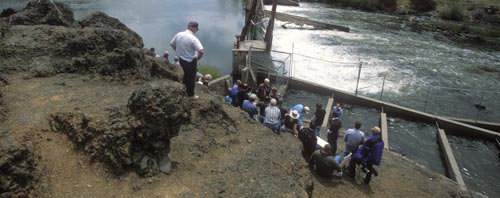
National Academy of Science at Chiloquin Dam, 2003. Photo by Anders Tomlinson.

A stop on 2003 NAS tour, the Chiloquin Dam, now removed, which blocked sucker habitat.

In the Klamath River Watershed there is little flat space. Where there is flat space with water running through it there are people, and there are few people living in the Klamath River watershed. The largest population is concentrated around Upper Klamath Lake in the Upper Klamath Basin where the Klamath River begins its 263 mile journey.

We Huddle in the Future’s Shade Waiting for Light.

bus tour of Klamath reclamation project for Klamath Indians sponsored by Klamath Waterusers Association.  Photo by Anders Tomlinson

2005 tour of Klamath Reclamation Project for Klamath Indians.

The Klamath Water Users Association presented a series of tours from 2001 through 2008 to introduce Klamath River Watershed stake-holders to the Klamath Reclamation Project. Anders documented two National Academy of Science panel tours, along with Pacific Ocean fishermen, News media, Klamath Indian Tribe and Upper Klamath Basin resident tours. All present had much in common. They are humans capable of doing “good” things and “bad” things in pursuit of their needs and expectations.

Lower Klamath National Wildlife Refuge Centennial Celebration, August 8th, 2008.  Photo by Anders Tomlinson..

Lower Klamath National Wildlife Refuge Centennial Celebration, 8-8-08.

The Centennial Celebration ended Anders’ shooting in the Klamath River Watershed.
Things had changed. The 114th Federal study of Upper Klamath Lake determined cattle should be kept away from streams and springs. Anders photographed in July 1995 cows wading across the Wood River that empties into Upper Klamath Lake. Access is now fenced off. Much has changed and much has stayed the same, it is the way humans do human things.

There are behaviors, relationships and synergies to celebrate. There are voices and concepts to listen to and consider. Polarization, ethnicity, projections, anticipations and fear of change shout louder, and have a larger audience, than seeking, understanding, embracing and compromise. It is here that these films of the Klamath River Watershed begin.

Anders Tomlinson walking in a forest near the klamath River in Oregon.  Photo by Jeff Ritter.

All water flows downhill, without the aid of man, uphill is another story.

These are stories of human nature reconciling itself with human nature.

©2011 Anders Tomlinson

Klamath Wildlife Refuge videos

For twelve thousands years man has been watching hunting wildlife here.

Overview and quick history of the landscape, wildlife and people that make the Klamath Basin National Wildlife Refuges what it is, a natural wonder of diversity.

In any season enjoy nature’s interplay in a majestic landscape.

A Year in the LIfe of the Klamath Basin National Wildlife Refuges. The six refuges span the Upper Klamath Basin from Klamath Marsh, east of Crater Lake National Park, to Tule Lake and Lower Klamath, north of the Lava Beds National Monument.

One Wildlife Complex – Six Refuges: Abundance and Diversity.

The Klamath Basin National Wildlife Complex is made of six refuges: Lower Klamath, Tule Lake, Clear Lake, Upper Klamath, Klamath Marsh and Bear Valley National Wildlife Refuges. These are wonderful places for all.

Managing resources to enhance wildlife and agricultural production.

Managing natural resources in the Klamath Basin National Wildlife Complex is a challenging inside its complexity. One feature is the Walking Wetlands program that rotates land from wetlands to farm fields on and off the Refuges.

The Nation’s first waterfowl Refuge celebrates its 100th birthday.

This is from a speech by Steve Thompson at the Lower Klamath National Wildlife Refuge Centennial Celebration on August 8, 2008. Steve had just retired as U.S. Fish and Wildlife Service Region Eight Manager – California and Nevada. He has been intimately involved with the water issues confronting the Klamath Reclamation Project. On this day, high winds were ripping across the basin. Digital audio repairs allow Steve’s speech to be shared with a minimum of wind and flag flapping distractions. Anders apologizes for the audio quality but the speaker’s intent is important.

A note: Steve speaks of certainty, but not sitting at the table, and unwilling to compromise, are the Endangered Species Act and Court systems. Ultimately, these two super-cede and dictate directions society must follow. In 2010, a dry year has curtailed, and will most likely reduce, water deliveries to the Klamath Irrigation Project. This also means Tule Lake and Lower Klamath National Wildlife Refuges will have less water delivered.
A balance is tipped and human ingenuity is at a premium.

©2010 Anders Tomlinson, all rights reserved.

Farmland videos

Growing up in Tulelake, California

Mary Palmer, daughter of a Klamath Reclamation Project’s World War II homesteader, shares her childhood memories of growing up in Tulelake. Life today, is much the same. The biggest difference is the water issues that now confront farmers and citizens in the Upper Klamath Basin.

Generation after generation raises our food and fiber.

A delightful ditty by Robert Ganey singing about living in the fields of America. Video shot in the farm land and Tule Lake National Wildlife Refuge surrounding Tulelake, California.

2010 Anders Tomlinson, all rights reserved.

Watershed videos

Tour of the Klamath River Watershed – The Big Picture.

Research for this video began looking for an existing concise physical description of the Klamath River Watershed. Anders learned that the watershed is not looked at in this manner. It’s story has been, and currently is, told in unconnected reports by various groups and agencies with distinct and differing agendas.

We have heard so much about salmon and the Klamath Basin Crisis. There is no one Klamath Basin. There is a Klamath River Watershed which comprises 10 to 12.5 million acres. It is made up of 13 watershed sub basins. It spreads across 2 states and 7 large counties. There are 7 national forests, 9 wilderness areas and 8 rivers in the overall watershed. 3 converging tectonic plates shape the watershed’s physiography. All of this together is a story of salmon habitat.

This is a Complex-Epic-Saga, It is Not A Convenient-Sound-bite.

The Klamath River extends some 340 miles from its headwaters to its estuary at the coast. Between 11- 13.4 million acre-feet of water flows into the Pacific Ocean during an average water year. Below Upper Klamath Lake there are at least 7,454 waterway miles in the Klamath River Watershed. Historically the Klamath River was a deep narrow river. Early miners en-route to settling Happy Camp thought The Klamath River was a tributary of the Trinity River.

An Unusual Watershed

Unlike typical watersheds the Klamath River watershed’s upper reaches are characterized
by flat topography, slow moving rivers and warm water fisheries. The Klamath River Watershed is upside down compared to most watersheds. The greatest relief and topographic complexity are below Upper Klamath Lake. The Klamath River begins a dramatic descent as it leaves Lake Ewauna and cuts through mountains on its way to the ocean.

Dry Top, Wet Bottom

The upper reaches of the Klamath River watershed are in the rain shadow of the Cascades. The upper watershed above Iron Gate Dam comprises 38% of the total Klamath River watershed area but provides 12% of the runoff.

©2010 Anders Tomlinson, all rights reserved.