A Year in the Life from Crater Lake to the Lava Beds

Visitors from Sweden enjoy Crater Lake's majesty.
photo-Anders Tomlinson

In Search of Majesty… a remarkable landscape

Upper Klamath Basin was once a large lake, Ancient Lake Modoc.
Today, the basin is enclosed to the west by the Southern Cascades,
Crater Lake- Mt. Mazama to the north, towering fault blocks to the east
and Medicine Lake Highlands to the south. Here are six National Wildlife Refuges,
Crater Lake National Park, Lava Beds National Monument, Modoc National Forest,
Winema National Forest, Mountain Lakes Wilderness Area and Sky Lakes
Wilderness Area. Several State and County parks and six history
museums dot the Basin. And there is water in all its many splendid forms.

Upper Klamath Lake as seen from a Running Y Ranch Resort ridge line.
photo-Anders Tomlinson

This is a land of four seasons. 30 to 50 degree temperature changes in a day
are common. Above the sagebrush, juniper, ponderosa, lodge pole, marsh,
lakes and rivers are moving skies that inspire one’s imagination.

History is here, protected by proud people. Geology is well represented by
evidence of many natural forces in action. This is a land of fire that has seen
flooding and drought numerous of times. It is not an easy place to live.
All must prepare for winter and a spring that can be harsh and seemingly unending.

Sparkling springs bubble up with cold clear water that turn into immediate creeks
and rivers. Migrating waterfowl find sanctuary and food here in the spring and fall.
One can learn much of the selfless effort required to raise young by watching the
wildlife care for there own during the summer and fall. It is not easy. Everything
has to be working together to make life sustainable. There have been times when
this wasn’t the case and wildlife, in all it’s splendid forms, left in search of survival.

Petroglyph Point in the Lava Beds.
photo-Anders Tomlinson

There are many reason this film should be seen?

The Upper Klamath Basin is a microcosms of planet earth. Shield volcanos
of Hawaii are mirrored by Medicine Lake Highlands. Water features from across
the world are here. Desert, seasonal and permanent marsh, forests, alpine features,
the earth is alive and growing with stratovolcanos and towering fault blocks.
And here, man has made his mark. Human settlers have been coming through here for
12,000 years. This area gives one opportunities that few places offer.
Here, is a story of an ever changing earth. And here is a reflection of man.

Anders on Klamath Marsh National Wildlife Refuge.
photo-Jeff Ritter

Producer – Director: dedication, discipline and desire.

Anders Tomlinson spent 12 years filming the Upper Klamath Basin. Projects included
films for Oregon Institute of Technology, Running Y Ranch, University
of California, U.S. Fish and Wildlife, Klamath Chamber of Commerce, Volcanic
Legacy All American Road, Oregon Governor’s Conference on Tourism,
Klamath Water Users and the California Waterfowl Association.
All of these films blend nature audio with music. Several musicians, song writers
and composers have visited me over the many years of this project. Their work
is the backbone to all my films.

©2010 Anders Tomlinson, all rights reserved.

Fields of Splendor

The spring waterfowl migration to Tulelake-Klamath Falls is a sight to behold. Millions have enacted this yearly passage for thousands of years. Fields Of Splendor follows the spring migration from early February through late May. It also visits arctic breeding grounds and California wintering spots including Sacramento and Sonny Bono National Wildlife Refuges. Common denominators are bodies of water surrounded by farmland.

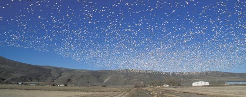
Snow geese rise off a farm field near Tule Lake National Wildlife Refuge.
photo-Anders Tomlinson

Watching a lake surface, or farm field, explode with a riotous rising of thousands of geese can take one’s breath away. One becomes part of the excitement as the geese circle overhead. How, and why, do they do what they do? Fields of Splendor makes sense of the coming and goings of Snow, Speckled and Canadian geese finding food and refuge on Tule Lake and Lower Klamath National Wildlife Refuges and Tulelake farmland. Spring Migration video.

The script for Fields of Splendor was written by Dr. Lawrence Powers. Soundtrack is by SonicAtomics. Editing will begin in the Fall or 2012.

©2010 Anders Tomlinson, all rights reserved.

Tulelake: Crossroads in History

Tulelake, California, just south of the Oregon border, was greatly impacted by the 2001 water shutoff. For numerous small family farms it was an unexpected end to a honorable way of life. Like all farmers, they had little security other than their faith that tomorrow would be a better day. And then the water was shut off…

Generation after generation raises our food and fiber.

Robert Ganey singing about living in the fields of America. Video shot in the farm land and Tule Lake National Wildlife Refuge surrounding Tulelake, California.

Under twenty feet of water…

Anders shooting southwest at Medicine Lake, Mt. Shasta and Tule Lake Basin.
Photo-Rob Crawford

A hundred years ago Tule Lake advanced and receded across the Tule Lake Basin. At that time, the current town of Tulelake was under twenty-some feet of water in the spring.
Much of the lake was a shallow evaporation pond. All of the Upper Klamath Basin, of which the Tule Lake Basin is part, is in the rain shadow of the Cascade Mountains. Throughout history, there have been wet periods and dry periods. Tule Lake would fluctuate accordingly. Today, the watershed above Iron Gate Dam comprises 38% of the Klamath River Watershed and provides 12% of the water, in a wet year.
For more geographical information visit Klamath River Watershed .

Looking at present day Tule Lake from Sheepy Ridge. photo-Anders Tomlinson

This is the northwest corner of the Great Basin. The Lost River began six miles east of Tulelake and traveled some 90 miles in a meandering circle north, west and south before draining into Tule Lake, not the Pacific Ocean. Today, a diversion canal sends much of the Lost River directly to the Klamath River.

The reclaimed lake bed, enriched with thousands of years of waterfowl migrations, has some of the planet’s richest soil. In an era of farmland constantly being taken out of production it is easy to make a case for good soil becoming endangered. This flies in the face of a concept that the next 50 years will require as much food to be raised as was grown in the past 10,000 years. Tulelake Irrigation District receives the vast majority of its water from the Klamath Reclamation Project. The district also has wells that were drilled during the 2001 water shutoff. A few farmers also dug wells.

Klamath Reclamation Project was the second effort, following Imperial Valley in Southern California, that proposed diverting water to promote developing the arid southwest. The Federal Government’s recent success building the Panama Canal provided tools, experience and brain power to rechannel rivers, build power dams, irrigate deserts and drain lakes into productive farmland. If people were to settle these developing lands they would need food and jobs. Farming offered both. For more information visit Klamath Reclamation history.

Farming and Refuge co-existing in Tulelake, California.
photo-Anders Tomlinson

Today, farming is looked at by many as a problem to be eradicated as if it were an infestation. These are the very same people who need food and water to exist. For those in the urban Southwest who want farming ended to save species there is another alternative, leave the southwest and reduce the demand on resources that many species need. Go somewhere that can support a human population along with the wildlife. This sounds extreme, but, reality is reality and human nature is human nature. Power and water demands need to subside in population centers. Each purchase or activity has multiple consequences, many unintended. Sitting in living rooms and writing checks for political movements and special interests doesn’t remove pressures created by cities which effect wildlife hundreds of miles away. As example, salmon are more impacted by urbanization than anything happening in rural America. Places like Tulelake do more per capita to help wildlife, and humans, than any Southwest city. Places like Tulelake export and provide. Places like San Francisco, Los Angeles and Phoenix import and receive. The story of Tulelake, truly a crossroads in history, is worth telling.
FFA, teaching the next generation how to provide.

Projects that have been shot in the Tule Lake Basin include Homesteading in a Promised Land, Fields of Splendor , Farmland , Walking Wetlands, Stepping Stones, Efficient Irrigation,
My Face Was My Crime, A Year in the Life and many others.
This is an American story of success told by the strong people who make their living off the land in a frontier setting.

©2010 Anders Tomlinson, all rights reserved.

Tulelake: A Graphic Rest Stop

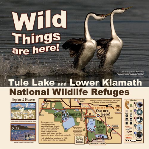
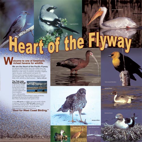
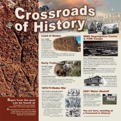
In 2008 Anders designed eight square panels, each 48 inches tall, for a community rest stop at the intersection of Highway 139, and Main Street in Tulelake. It clearly showcases places and things one can enjoy if they leave the highway and explore the surrounding landscape.

Here is California's beginning or end depending on the direction one is driving.

All of this within 39 miles from this rest stop

The adventure begins as history comes alive off the beaten path.

Visit the largest concentration of bald eagles in the lower 48 states

These are the first waterfowl refuge and a wildlife - agricultural oasis.

Many naturalists list the Klamath Basin as “Best for West Coast Birding”

At least 489 species of wildlife visit or live in this volcanic wonderland.

A magical place, well worth visiting any time of year

Explore North America's greatest concentration of lava tube caves.

You are here, standing at a Crossroad in History!

For 12,000 years humans have roam this land.

This is the second Reclamation Project as the USA looked to expanding west

In the beginning the challenge was removing water.

Some of the first steps to land on the moon were here.

The Volcanic Legacy All-American Road runs through here.

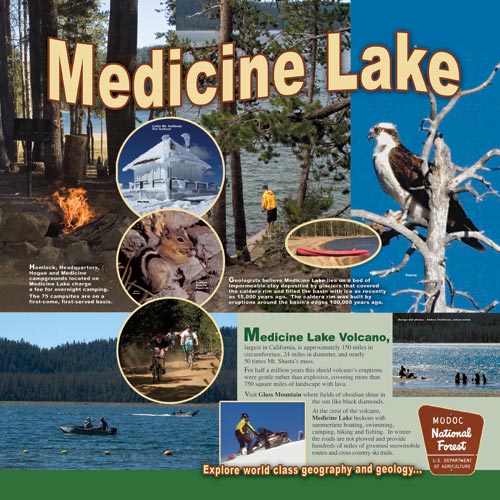
The largest Volcano in California: 24 miles in diameter, 150 miles in circumference

750 square miles of landscape is covered with lava.

The Little Rest Stop with A Big Story

Here are eight panels, 4' x 4', that share epic tales and wondrous landscapes.

©2010 Anders Tomlinson, all rights reserved.
“Watershed Moments”

A film by Anders Tomlinson, “Watershed Moments“, is going into post-production. Filming began in Rocky Point, Oregon during the summer of 1995 and continued throughout Upper Klamath Basin and the Klamath River Watershed. Filming concluded in 2008.
 

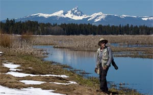
It was here on a late September day, while waiting to film white water rafters, that Anders learned Southern California can directly effect Klamath River flows.
photo-Jeff Ritter

This is not a story of fish vs. potatoes or Indians vs. Farmers. This is not a film of sound bites and confrontation. This is a film of human nature. And in a broader sense it is a film of human nature’s effect on wildlife and habitat. The springs of Upper Klamath Lake and surrounding country including Crater Lake National Park, Fort Klamath and Chiloquin were the first scenes filmed. The Centennial Celebration of the Lower Klamath National Wildlife Refuge, a study of an emerging “Walking Wetlands” on Tule Lake National Wildlife Refuge, and followup interviews with agricultural leaders from the 2001 Klamath Reclamation Project Water shutoff were the last scenes filmed.  

The Klamath Reclamation was the second Federal effort to settle the West.  “Watershed Moments” begins with the history of the Upper Klamath Basin and ends with current pressures Klamath Reclamation Project faces from Endangered Species Acts triggered by Sucker fish in Upper Klamath Lake, Coho Salmon along the Klamath River Watershed and water diversions from Trinity River to the Sacramento River and points south.  This is monumental story that reflects all aspects of human nature.  It is a story of populations in flux.  It is a story of unintended consequences. And it is a story of Modern Man.
National Academy of Science report.

©2010 Anders Tomlinson, all rights reserved.